|
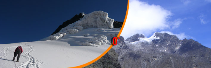
On the highest
peaks of the Rwenzori
After several days
of incessant rain, while Cagni is ascending the Mobuku
Valley at forced stages, Luigi Amedeo of Savoy, Erminio
Botta, the four guides from the Aosta Valley and a small
group of Bakonjo porters leave to climb the highest
peaks of Rwenzori on June 15th. From Bujungolo, having
turned into a small valley which opens off the right
side of Mobuku Valley, they ascend to Freshfield Pass
(4326m) on the crest of the watershed. From here they
descend to the west of Baker and make camp II at 4045
metres, in the neighbourhood of the first small lake.
The following morning while Brocherel, Laurent Petigax
and three native porters turn back to retrieve some
discarded loads, the others continue northwards to the
bottom of the walls of Baker, opening a trial between
groundsel and helichrysum. Camp III is set up at altitude
4219 at the foot of the westerly slope of Baker, under
the vertical cliffs of the two peaks climbed by the
Duke six days before.
On June 17th the party ascend to Scott Elliot Pass (4347m),
continue along the ridge towards the west until they
near the ice flow which falls below the southern peaks
of Stanley and set up camp IV at altitude 4516m. A rapid
check of the provisions results in rations being sufficient
only for a few days. Part of the group must therefore
return, so Laurent Petigax and Erminio Botta undertake
to accompany the team of Bakonjo to Bujungolo. In the
meanwhile Joseph Petigax, Ollier and Brocherel push
on in reconnaissance towards the central group.
The next morning divided into two roped couples (the
Duke of the Abruzzi with Brocherel and Joseph Petigax
with Ollier) the mountaineers reach a great icy plateau
in an hour. The weather is cloudy and promises no good,
but they go ahead anyway. Petigax and Ollier lead; the
Duke heads the second roped party. The two highest peaks
of the group are silhouetted there in front of them,
covered with snow and ice. The southernmost one displays
a wall of vertical rock towards the east and is surmounted
by a large cornice of snow.
Mount Stanley from Freshfield Pass. Photo by
Vittorio Sella.
The other shows “a peak and ridges edged with
the most majestic cornice imaginable, sustained by countless
stalactites and ice needles which, from a distance,
seemed a gala of snow – white lace”.
Petigax marks
out the piste without pausing and in fog and mist the
party reach the foot of the large south –eastern
ridge of the southern peak. Climbing on compact snow,
which only needs to have steps cut in it every now and
then, the two roped couples reach the first summit at
half past seven. It is Alexandra Peak whose height is
estimated as being 5105 metres. Visibility is poor,
and the vague outlines of the highest peaks appear to
the north out of the fog only for a few moments.
At nine in the morning the group decide to continue.
They will attempt the shortest and most direct path.
With faces to the mountain, using the steps dug out
on the spot by Petigax, the Duke and his guides descend
to the pass between the two peaks, a “ribbon of
ice suspended between two wide crevasses”. Here,
abandoning all excess material, they attack the steep
wall. Petigax is always in the lead and is continually
cutting steps with great blows of his ice-axe, making
“a hail of snow and ice” rain down on his
companions below. The gradient makes itself felt, to
the point that “from below, the wall immediately
disappeared from sight into the mist and seemed to be
suspended above an abyss with no bottom”.
Having arrived below the cornice, between stalactites
and stalagmites, the explorers circle around the ice
colonnade looking for a passage through at a point where
the ice architecture is anchored to the wall. They discover
a cleft – really a vertical canal a couple of
metres high. Ollier positions himself as a firm support.
Petigax climbs onto his shoulders with his spiked boots,
then onto his head; he wedges his ice axe above the
cornice and pulls himself up onto the crest. It’s
done. A few minutes climb more along the ridge and there
it is; the top: Margherita Peak, 5125 metres, the highest
peak in the Rwenzori. A sea of fog stretches out to
infinity a few metres below but up here the sun is shining.
The Duke of the Abruzzi unfurls to the wind the small
Italian flag given to him by Queen Margherita before
his departure.
In the early hours of the afternoon the group is once
more at the small tent of camp IV. The first symptoms
of ophthalmia are not long in making themselves felt.
Because of the poor visibility nobody had worn dark
glasses and now the climbers were struck by temporarily
blindness.
They wait in the tent for a day, and as soon as this
troublesome snow-blindness passes a little, the team
returns to Alexandra Peak to measure “the angles
of the peaks and the salient points of the range”.
Back again on the icy plateau, Luigi Amedeo and his
guides now aim southwards towards the other two peaks
of Stanley. They attack the nearest one from the eastern
gorge; higher up they move onto the rocks on the left,
and then again re-enter the couloir. From a cleft in
the ridge they then move towards the Congolese side
and finally after climbing up rock faults, come out
on the summit of Elena Peak at 4995 metres.
An hour later it is again time to redescend. The roped
parties lower themselves along the southern crest up
to the narrow cleft between the two peaks where there
is a sharp rocky gendarme. They go round the obstacle
keeping to the Congolese side; they climb a snow –
covered rise and then on rocks until they emerge on
the top of Savoia Peak at altitude 4980. The exploration
of Mount Stanley can be said to be concluded.
During their descent the mountaineers inaugurate a new
path: they proceed to the south of the glacier which
covers the summit; descend the rocky east wall and in
the end slip into a gorge which takes them back to the
glacier.
The evening and the next day there are celebrations
at camp IV. The other mountaineers of the expedition
have arrived up here from Bujungolo and they all talk
over the events of the past days. Everybody has contributed
something especially Sella with his camera, but also
Roccati and Cavalli. The first two in particular who
on June 19th climbed up to the western ridge of Stairs
Peak (4950m), in the southernmost group of the Rwenzori,
departing from Freshfield Pass. With the passing of
the days the expeditions begins to gather the fruits
of its laborious explorative work, but other ascents
are still waiting for Luigi Amedeo of Savoy and his
companions. On June 22nd taking leave from his friends,
the Duke of the Abruzzi sets off again with the guide
Joseph and Laurent Petigax and five Bakonjo porters.
Their objective: the peaks of Mount Speke.
From camp IV the group descends towards Lake Bujuku
and then, at altitude 3933, makes for the north, towards
the southern wall of the group to explore. Having cross
over the crest of the watershed, the explorers circle
round the foot of the south western ridge of Speke and
then horizontally cross the west wall, keeping a short
distance from the glacier. At altitude 4475m, right
under Vittorio Emanuele Peak, camp V is set up.
The next day the weather does not look at all promising
but the climbers decide to continue all the same. They
climb unroped along the big western ridge and in one
hour first over rock and then snow, they reach Vittorio
Emanuele Peak (4901m). They patiently wait many hours
for the weather to lift, but the fog shows no sign of
lessening up.
The next two days bring more bad weather. A reconnaissance
attempt towards the Emin group is abandoned due to rain,
snow and hail. It only clears on the evening of June
25th. At down the next day, after a freezing night,
the group starts off again and in a short time reascends
to Vittorio Emanuele Peak for topographical observations.
Everything proceeds very quickly and by seven o’clock
in the morning the Duke and guides are again back at
their tent. It is a beautiful, hot day. In the evening
some Bakonjo join the camp bringing food and supplies.
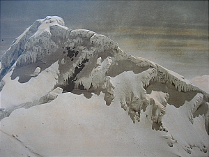
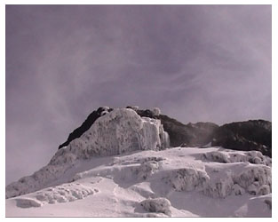
Margherita peak , 5109m photo by Vittorio Sella.
The next day at dawn they start out again.
It is to be a long day, first towards the North and
then eastwards, to the base of Mount Emin. That evening
the guides set up the camp VI at altitude 4244, a few
hundred metres below the Umberto Glacier.
On June 28th the sky is again covered but they try nevertheless.
The ascent path follows the spur which falls from the
highest peak of the group, between the Emin and Umberto
glaciers. At 4485 metres a tent is pitched (it will
be camp VII); Luigi Amedeo Ollier and the two Petigax
continue climbing immediately.
First they proceed on snow, then they turn west towards
a large ridge of rock. They follow the veining of the
rock and shortly reach Umberto Peak, estimated at 4815
metres, where they erect a great “pyramid”
of stones. Visibility is practically nil, and nothing
changes with waiting.
On the morning of June 29th the Duke would like to repeat
the climb but the weather is increasingly worse. What
is more, they only have food for one more day and the
road to Bujungolo is very long. They go back.
On the evening of June 30th after a long stretch under
the rain, the group sleeps at camp II. Next day having
crossed Freshfield Pass where Sella and Botta have camped
for their photographic work, the Duke and his guides
set foot again in the Bujungolo base camp. They have
been at an altitude of more than 4000 metres for a good
seventeen days.
Top
Frenetic activity
During Luigi Amedeo’s
absence the other members of the expedition have not
remained inactive by any means. On June 22nd Cagni,
Cavalli and Brocherel scaled Alexandra Peak. Three days
later after leaving camp IV above Scott Elliot Pass,
Sella, Botta, Brocherel and Roccati reached Moebius
Peak on Mount Stanley; its first ascent. And then the
next morning the first three succeeded in concluding
the fourth ascent to Alexandra Peak. Even more: for
photographic reasons Sella again returned to the Alexandra
Peak, this time with Roccati, on the morning of June
27th. A proper tour de force. And it’s not finished
because after the return of the Duke to Bujungolo, Sella,
Botta and Brocherel climb to Edward Peak on Mount Baker
a new way, the south crest, on July 2nd (this climb
will be repeated by the head of the expedition for photographic
reasons on July 5th and 7th); and still more, on the
4th the same roped party reach the central peak of the
Luigi di Savoia group (4659m, later to be named Sella
Peak).
Lastly it is necessary to mention another two ascents,
done on July 8th and 12th, along the west ridge of Stairs
Peak (luigi di Savoia group), by the Duke of the Abruzzi
and Victorio Sella respectively.
Also on July 8th Cagni Peak (4519m) was scaled to the
North of Bujungolo, by Brocherel, Joseph Petigax and
Cagni (this last is to return to the peak the next day
for photographical surveys).
By now exploration of the range is virtually concluded.
But on July 9th Luigi Amedeo, Ollier and Joseph Petigax
once more reach the summit of Wollaston Peak (4659m),
up till then inviolate, having climbed along the eastern
gorge and the southern ridge; and straight afterwards
they conclude the crossing of Moore Peak descending
to the Grauer Pass.
To mention finally another two climbs by Sella on July
11th and 12th both for photographic reasons, to Edward
Peak on Baker and to Stairs Peak in the Luigi di Savoia
group.
At this point there remains only Mount Gessi to explore,
the most remote. While part of the expedition gets ready
for the descent towards Fort Portal, Luigi Amedeo, Joseph
Petigax, Ollier and some porters climb to Freshfield
Pass and reach camp III under the western slopes of
Bakeron July 13th. Then the next day they cross over
Scott Elliot Pass and descend to the banks of Lake Bujuku
(3918m), from where they proceed downwards along the
torrent. In the end they set up camp IX at 3506 metres
that evening.
The following day the group ascends a small valley and
descends into the upper Migusi Valley. Camp X is set
up at altitude 4166, at some hundred metres from the
terminal face of the Iolanda glacier, in the face of
wonderful scenery.
On the morning of July 16th before dawn the Duke and
his guides climb unroped up a gorge and then, still
unroped continue on the rocks of the south east ridge
to the 4769 metres of Iolanda Peak. To finish with after
a break the explorers proceed along the snow covered
ridge towards the north and reach the summit of Bottego
Peak (4719m). This time their climbing campaign is really
finished.
Next day the group descend along Bujuku Valley and pitch
their XI camp below the narrow passage of the Portals,
at altitude 2910; finally on July 18th they join the
rest of the expedition at Ibanda camp, now on the road
for Fort Portal.
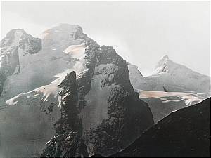
Mount Stanley. Photo by Vittorio Sella
Top
The results of the
expeditions
The results of their
mountaineering explorative campaign are outstanding:
from June 10th to July 16th seventeen peaks have been
climbed and a good twenty eight ascents, including repetitions,
have been brought to conclusion. The scientific results
of the expedition are remarkable tooand are to be illustrated
in two volumes, Il Rwenzori: relazioni scientifiche,
published in 1909 by Hoepli of Milan. The first is about
zoology and botany; it is edited by a rich equipe of
scientists and illustrates the results of the studies
and observations carried out on the specimens collected
on the expedition. The second, coordinated mainly by
Professor Roccati, is about geology, petrography and
mineralogy.
The geographical,
astronomical, geodetical and meteorological observations
are instead contained in two bulky appendices in the
official volume of the expedition, Il Rwenzori: viaggio
di esplorazione e prime ascensioni (Hoepli, Milan, 1908),
edited by Filippo de Filippi and illustrated by Vittorio
Sella, author of the splendid, rich photographic documentation
still unsurpassed today for its beauty, of the great
African mountain.
Finally the map in scale 1:40.000 of the Rwenzori must
be remembered; the “most important result of the
expedition” drawn up with the data from the numerous
angular measurements made by the Duke of Abruzzi from
the various peaks climbed, and completed by the measuring
of 300 metres prepared by Comander Cagni near Bujungolo.
From study of the map, whose toponymy is due to a study
meeting between Luigi Amedeo, Sir Harry Johnson and
Dr. Stuhlmann, it results that the watershed with the
main peaks (that is the entire snow covered range) is
nineteen kilometres long and that the area covered by
glaciers is little wider than 11.5 km from north to
south, and 6.5 km from west to east. Quite an area especially
if one considers its location in the heart of the African
continent.
Ptolemy and the ancient geographers really were right:
the mysterious Mountains of the Moon are worthy of so
much attention and devotion.
From “The
Rwenzori Discovery- Luigi Amedeo di Savoia Duca degli
Abruzzi”, by Roberto Mantovani, Museo Della
Montagna 1996.
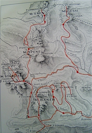
The itenerary of the expedition of the Duke.
See also
A great, new mountaineering expedition
The first Ascents.
On the highest peaks
of the Rwenzori
Top
|